Thursday, 31 October 2019

ANTARCTICA

ANTARCTICA 

Antarctica Facts;

1. Antarctica Is The Least Populated Continent Of Our Planet. The Word 'Antarctica' Comes From The Greek Term 'Antarktike' Meaning 'The Opposite To Arctic' Or 'Opposite To North'.

There are no countries in Antarctica, although seven nations claim different parts of it: New Zealand, Australia, France, Norway, the United Kingdom, Chile, and Argentina

2. According to size, Antarctica is the fifth largest continent of our planet. The continent is almost double the size of Australia!

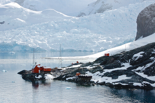
3. Antarctica is an ice covered continent surrounded by the Southern Ocean. Almost all of the continent's land is covered by a thick layer of ice.

4. Antarctica is the driest continent of the seven continents. Antarctica is an icy desert with very little rainfall throughout the year.

5. Antarctica is the windiest place on the earth where windspeed of more than 350 kilom.etres per hour/218 miles per hour have been measured.

6. Antarctica is the least populated continent. There are no residents living permanently here. Only around 1,000 people (in winter) and 10,000 people (in summer) live on the continent. 

7. Highest continent: Antarctica has the highest average elevation of all continents. Most of the continent is higher than 3,000 m/9,900 ft. above sea level. The highest mountain on Antarctica is Mount Vinson at 4,900 metres/16,000 ft.

ASIA

Dear Students,
Welcome to our lesson today.
Learning Objectives:
1. Name, locate and identify facts of the Asia continent, five countries , capital cities.
2. Explore on the different physical features in the selected countries.

5. ASIA
FACTS ABOUT ASIA.

1. Asia is the largest continent of our planet, both in size and also when we consider the population.
2.There are 48 countries in Asia.  Two of the Asian countries also share part of the European continent; these countries are Russia and Turkey
3.More than 4.4 billion people live on the continent. Asia is thus the most populous continent.
4. Largest Country: Russia by land are, even though roughly 40% of the country belongs to the European continent. China is the largest country by population.
5. Largest City: Shanghai in China. With more than 24 million inhabitants Shanghai is also the largest city in the world by population.
6. Smallest Country: Maldives. The Indian ocean country is one of the smallest countries in the world and Asia's smallest country.
7. Borneo in South-East Asia is also the third largest island in the world and the largest in Asia. The island belongs to three countries; Malaysia and Brunei in the north while Indonesia claims the southern part of the island.
8. Yangtze River is the longest on the Asian continent. It is in China. (6,300metres/3,915miles).
9. Mount Everest. The mountain (8,849metres/29,035ft) is located in the Himalayan mountain range.
10. Biggest Lake: Caspian Sea. The coastline is shared by five countries: Russia, Turkmenistan, Kazakhstan, Azerbaijan and Iran.
11. Driest Place: The Gobi desert is the largest desert in Asia and the fifth largest desert in the world. This is a cold desert where the temperatures can be very low and sometimes even snow can occur.


NORTH AND SOUTH AMERICA

Dear students,
Let us explore about North America and South America's continents, countries, capital cities and physical features.

Learning Objectives.
1. explore North and South America's continents.
2. Learn about the countries, populations, capital cities and physical features.


According to this website: https://www.kids-world-travel-guide.com/continent-facts.html


3. NORTH AMERICA.  


North America Facts
1. There are 23 countries in North America with a total of more than 579 million people living on the continent.
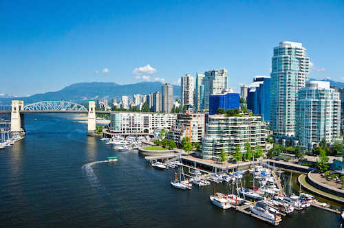
Vancouver skyline in CanadaVancouver in Canada
2. Largest Country: Canada. The country is covering almost half the North American continent's land area. Canada is slightly bigger than the USA and about as big as China.
3. Largest City: Mexico City, which is the capital city of Mexico with a population of about 9 million. 
4. Smallest Country: St Kitts and Nevis with only about 54,000 inhabitants. This island country is located in the Caribbean Sea. 
5. Biggest Island: Greenland. This is also the world's largest island that is not a continent! Greenland is located in the North Atlantic Ocean. - Australia is also an island, but considered a continent.
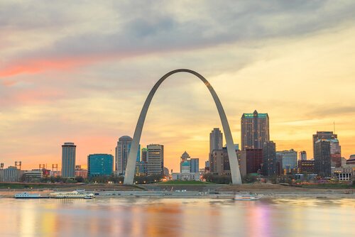
6. Longest River of North America: Missouri River/USA (3,767 metres/2,341 miles). The Missouri River flows through seven states of the USA: Montana, North Dakota, South Dakota, Nebraska, Iowa, Kansas and Missouri. Together with the Mississippi River, it forms one of the largest river systems in the world.
St Louis in twilight - image ShutterstockSt Louis on the Mississippi River - which the Missouri joins just north of the city
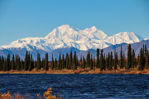
7. North America Facts: Highest Mountain: Denali in Alasaka/USA. The mountain (6,190 metres/20,310 ft) is located in the Alaska mountain range. 
Mount Denali in Alaska - image shutterstockMount Denali in Alaska
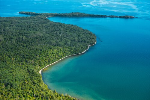
8. Biggest Lake: Lake Superior. This is the largest of the Great Lakes in the USA. Lake Superior is shared by Canada (to the north) and the United States (to the east, south and west). 
Lake Superior is also considered the largest freshwater lake by area in the world.
Thunder Bay/Lake Superior - image by lastdjedal/shutterstockLake Superior's Thunder Bay as seen from the Sleeping Giant
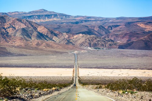
9. Lowest Point: Death Valley. In the Death Valley National Park you will not only find the lowest point in North America with 86 m/282 ft. below sea level, but this is also the hottest and the driest national park in the USA. 
Death Valley in California
10. North America Facts: There is no landlocked country in North America.

4. South America

South America Facts

1.South America is the fourth largest continent in size and the fifth largest when we consider population.
2. There are 12 countries in South America with a total of more than 385 million people living on the continent.
3. Largest Country: Brazil. The country is covering more than half the continent's landmass.
4. Largest City: Sao Paolo in Brazil. With more than 21 million inhabitants (2019) Sao Paulo is also one of the ten biggest cities in the world.
5. Smallest Country: Suriname. The country is one of the 10 most sparsely populated countries in the world.
6. Biggest IslandTierra del Fuego (Spanish meaning: Land of Fire), at the southern tip of Argentina and Chile
7. Longest River: Amazon River (6,437metres/4,000miles). The Amazon is not only the second longest river in the world after the Nile.
8. Highest Mountain: Aconcagua in Argentina.
9. Biggest Lake: Lake Titicaca (shared by Bolivia and Peru)
Countries and cities of North and South America.


Tuesday, 29 October 2019

EUROPE AND AFRICA

Welcome students on exploring specific continents, countries and capital cities with physical features.

1. EUROPE:

FACTS ABOUT EUROPE:'


Europe is the second smallest continent in size but the third 
largest in population.
The European continent has 50 countries with a total of more 
than 742 million people
The European continent is located completely in the northern 
hemisphere and mainly in the eastern hemisphere.
The three largest countries are; Russia, Ukraine and France.
Largest city: Moscow. The Russian capital city has more than 13
million.
Smallest country: Vatican City is the smallest country not only in 
Europe, but also in the world.
Biggest island: Greenland is the largest island in Europe - and in 
the world.


2. AFRICA


FACTS ABOUT AFRICA


The African continent is located mainly in the Eastern hemisphere 
and to the major part in the Northern hemisphere.
There are 54 countries in Africa with a total of more than 1.1 
billion people.
Largest Country: Algeria. This country is among the ten largest 
countries in the world.
Largest City: Lagos in Nigeria. With more than 21 million people.
Smallest CountrySeychelles, which is an archipelago (nation of 
islands) in the Indian Ocean.
Biggest Island: Madagascar in the Indian Ocean.
Longest River: Nile (6,852metre). The Nile is the longest river in 
the world.
Highest Mountain: Mt Kilimanjaro in Tanzania.
Biggest Lake: Lake Victoria (bordering 
Uganda, Tanzania and Kenya).

The Sahara in northern Africa is the largest hot desert in the 
world.


Click on this link to learn about Facts about continents


CONTINENTS, COUNTRIES, CAPITAL CITIES 1/2

Dear Students,
Welcome back to Map work to explore  Continents, Countries and Capital Cities and Physical features.

Learning Objectives:

1. Students name and locate the world’s continents and oceans
2. Students identify specific continents, countries, capital cities and physical features of chosen countries.


The Earth


The Earth is mostly water
¾ of the Earth is covered in water
The big bodies of water on Earth are called oceans
The big pieces of land on Earth are called continents


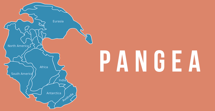
. The Earth once had one continent called Pangea. which was a supercontinent.
Pangea began to break up about 200 million years ago as a result of the movement of the Earth's tectonic plates and mantle convection.
. Pangaea started to break up into two smaller supercontinents, called Laurasia and Gondwanaland.


Task 1.

World Map Jigsaw

Student Instructions:

1.       Use the jigsaw puzzles of world map
2.       Rearrange the shapes so they look like the world map
3.       Write the names of each continent on the map
4.       Add any other mapping features you think are missing
5.       Name as many seas as you can
6.       Locate and name as many countries as you can
7.       Locate and name as many capital cities as you can

More facts about Continents click on the link below;
https://www.kids-world-travel-guide.com/continent-facts.html

Sunday, 6 October 2019

RENAISSANCE PROJECTS

Dear Students,

Welcome to another exciting topic in Renaissance Art. In this topic, we will explore the history of renaissance, and focus on art. 

Learning Objectives:

- Explore and analyze the history of Renaissance Art and its impact on artists and society.
- Apply the different art skills and produce 2D  and 3D artistic pieces; 


  1. stained glass crafts.
  Stained glass, in the arts, the colored glass used for making decorative windows and other objects through which light passes.
- Recycle plastic cups, water bottles, small glass bottles.
- Use sharpies, permanent markers, if possible glass paints.


  1. Tapestries crafts
  Tapestry is art made with threads. In this way, a colourful pattern or image is made on fabric with paintings.


Miniature Portraits.


RENAISSANCE ART

What is the Renaissance Period?

The Renaissance was a period of time from the 14th to the 17th century in Europe. 
This era bridged the time between the Middle Ages and modern times. 
The word "Renaissance" means "rebirth".

The Renaissance was a time of "coming out of the dark". It was a rebirth of education, science, art, literature, music, and a better life for people in general.

Was called the Dark Ages because so much of what was learned earlier was lost with the fall of the Roman Empire.

Many of the new ideas and attitudes that marked the Renaissance times were portrayed in art.

Renaissance art is often divided up into two periods:

Early Renaissance (1400-1479) - Artists learned by trying to emulate classical artists focusing on symmetry and creating the perfect form. This era featured such artists as Giotto, Masaccio, and Donatello.

High Renaissance (1475-1525) - A rising interest in perspective and space gave the art even more realism. Great artists such as Michelangelo, Leonardo da Vinci, and Rafael flourished during this period.

Change of Subjects

In the Middle Ages the subject of almost all European art was religion, specifically Christianity and the Catholic Church. Although Renaissance artists continued to paint religious paintings, they also branched out to other subjects including Greek and Roman mythology, historical subjects, and portraits of individuals. They also focused on the details of everyday life.

School of Athens
School of Athens by Raphael
featured philosophers such as Plato, Aristotle, and Socrates

Realism

One of the big changes in art was to paint and sculpt subjects realistically. This is called realism and involves a number of techniques that make the subjects and background look like they would in real life. This also meant giving the subjects more emotional qualities.

New Techniques and Styles

Many new techniques were introduced during the Renaissance. These techniques helped to enhance the quality and realism of the art.

Perspective - perspective is drawing or painting a picture such that it looks like there are three dimensions. It gives the illusion that some objects in the painting are further away than others.

Balance and Proportion - Drawing subjects such that they are the correct size when compared to each other.

Use of Light and Dark - Many artists starting using light and shadows in their works to add drama, perspective, and timing to their art.

Caravaggio's use of  light and shadow
The Calling of Saint Matthew by Caravaggio
Caravaggio used light and shadow to create drama


Sfumato - This was a technique used by Leonardo da Vinci to add additional perspective and dimension to paintings. It was a way of blurring the lines between subjects. This technique was used in Leonardo's Mona Lisa.

Mona Lisa
The Mona Lisa by Leonardo da Vinci used the sfumato technique


Foreshortening - Another technique that added perspective and depth to paintings, foreshortening is a way of shortening lines to give the illusion of depth.

More information found on; https://www.ducksters.com/history/renaissance_art.php

LOCATE PLACES USING COORDINATES

 Map Coordinates


}You can also locate places using map coordinates.
}Coordinates are the X-axis, (latitudes), horizontal lines.
} Y-axis, longitudes, vertical lines.
}Start with horizontal or latitude or X-axis first then second use vertical or longitudes.
}If you have a coordinate (B, 2), B is horizontal line while 2 is the vertical line. Where they meet, that is the point of intersection.


You can locate places using Google-maps. click the link below.


CLASS PROJECT ON MAP READING SKILLS.

- You will be required to work in a group of 3, 4, and 5 or individual to design a map of any place. The place could be;
1. a mall.
2. TBS
3. Souk
4. town.
5. City
6 stadium.
7. House
8. Imaginary town or city or any other place.

- In your map, include all the features of that specific place.
- Your map must have; title, key and compass.
- The map MUST  be sketched, drawn, painted or  color coded correctly at school
- This project has to be ready before Thursday for presentation.
- use A3 paper or manila paper, pencil, ruler, eraser, colors, paint.